- confirmed flights are good to go
- overcast in Napanee, however there is a snowstorm coming later today (see below)
- Darcy (our tour guy) is flying from Toronto to Montreal. He will meet us when the bus arrives at Pierre Elliott Airport
- airline has WiFi
- Lufthansa is serving Pasta or Chicken this evening

- all we need is the bus to show up at 1:00pm so we can travel down the 401 to Montreal where our journey will begin

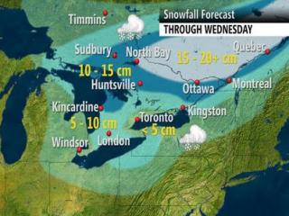
A low developing over the southern United States will push into central Canada on Tuesday and rapidly intensify.
Precipitation will start as light rain, but as temperatures drop Tuesday evening, the rain will change to snow. Parts of eastern Ontario, including the Ottawa Valley, could see up to 15 cm by Wednesday.
In Quebec, snowfall amounts could be even higher, with Montreal expected to see about 20 cm of snow.
Snowfall warnings are in place for both cities; a winter storm warning has been issued for Quebec City, the Laurentians and the Saguenay region.
The system will also bring a wintery mix to parts of southern Ontario, including Toronto, Hamilton, Niagara, Kitchener-Waterloo, Kingston and cottage country.
The region will also initially see rain throughout the day Tuesday, but a cold front associated with the system will cause temperatures to plunge Tuesday night, meaning any subsequent precipitation will be snow.
Weather Network meteorologist Chris Scott says it's still too early to say whether the Greater Toronto Area will see any significant accumulations, as it will depend on how quickly the system sweeps through.
“A slight change in the timing of the temperature transition can change the outcome significantly,” he explains. “While the GTA doesn't get the worst, this will likely be the first time this winter that travel will be dicey for most of the population as the slop of Tuesday evening freezes up overnight.”
No comments:
Post a Comment